
Locations
UDC-CC Campuses
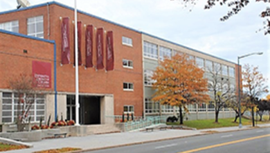
Lamond-Riggs Campus – NE
5171 S. Dakota Ave. NE
Washington, DC 20017
(near the Fort Totten Metro station on the Red, Yellow, and Green lines)
The Lamond-Riggs Campus (formerly the Bertie Backus Campus) serves students pursuing associate degrees or certificates, which include law enforcement, information technology, engineering sciences and accredited programs, such as nursing, mortuary science, respiratory therapy, and aviation maintenance technology. It is home to the Bertie Backus Building (listed as Building 54 in the course catalog and guides).
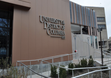
Van Ness Campus – NW
4200 Connecticut Avenue NW
Washington, DC 20008
The Van Ness campus is the site of UDC-CC’s mortuary science program.
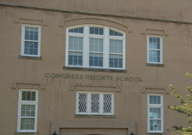
Congress Heights Campus – SE
3100 Martin Luther King Jr SE
Washington, DC 20032
Congress Heights is home to the Division of Workforce Development and Lifelong Learning (WDLL). The law enforcement/corrections administration program and education: conc. infant/toddler program are also located here.
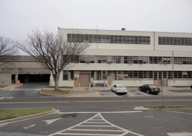
Reagan National Airport, Hangar #2
2801 Thomas Avenue, Hangar #2
Ronald Reagan Washington National Airport (DCA)
Washington, DC 20001
Home to the aviation maintenance technology certification and degree programs.
DIRECTIONS
UDC-CC CAMPUSES
Directions to the Lamond Riggs Campus – Ward 5
Address
5171 South Dakota Avenue NE
Washington, DC 20017
Directions by Metro Rail
Fort Totten Metro Station (near Bertie Backus Campus)
View Metro Map
550 Galloway Street NE.
Metro Line: Green, Red, and Yellow Lines
Metro Schedule: Opens at 5:00 AM (M-F).
Metro Parking: There Lot with 32 short-term metered spots. Parking is available Monday – Thursday 8:30am – 3:30pm and Friday 7:00pm – 2:00am. Reserved rate: $65.00.
Bike Parking: There are 10 bike racks and 6 lockers at this station.
Metro Entrance: The entrance is at 1st Place and Galloway St., NE
Directions by Metro Bus
Bertie Backus Campus
View Metro Map
550 Galloway Street NE. Washington, DC 20011.
60 GEORGIA AVE-PETWORTH
64 FEDERAL TRIANGLE
80 KENNEDY CENTER
80 MCPERSON SQUARE
E2 IVY CITY
E4 FRIENDSHIP HEIGHTS
F6 NEW CARROLLTON
K2 TAKOMA
K6 WHITE OAK
K9 FDA/FEDERAL RESEARCH CENTER
R1 ADELPHI
R2 CALVERTON
Directions to Van Ness Campus – Ward 3
Address
4200 Connecticut Avenue NW
Washington, DC 20008
Directions by Metro Rail
Van Ness Metro Station (on Van Ness Campus)
Metro Line: Red Line
View Metro Map
Directions by Metro Bus
The following bus routes go to UDC (Van Ness Campus):
Driving Directions
From Maryland:
- Take I-495 beltway
- Exit 33 MD-185 s Connecticut Ave towards Chevy Chase
- Continue around roundabout
- Take 4th exit continue on Connecticut Ave
- Then turn right on Van Ness 4.6 miles
From Virgina:
- Take I-295 North towards DC
- Take 14th Street bridge
- Turn left on I Street
- Then turn right on Connecticut Ave
- Continue on Connecticut Ave
- Then turn left on Van Ness 3.9 miles
Directions to Congress Heights Campus – Ward 8
Address
3100 Martin Luther King Jr SE
Washington, DC 20032
Directions by Metro Rail
Congress Heights Metro Station (near Congress Heights Campus)
View Metro Map
3100 Martin Luther King Jr. Avenue, SE, Washington, DC 20032.
Metro Line: Green Line.
Metro Schedule: Opens at 5:00 AM (M-F).
Metro Parking: There is a Kiss & Ride Lot with 67 short-term metered spots. Parking is not allowed between 2:00 AM and 8:30AM, and 3:30 PM to 7:30 PM.
Bike Parking: There are 10 bike racks and 12 lockers at this station.
Metro Entrance: The entrance is at Alabama Ave & 13th St SE.
Directions by Metro Bus
Congress Heights Campus
View Metro Map
3100 Martin Luther King Jr. Avenue, SE, Washington, DC 20032.
W2 UNITED MEDICAL CENTER
W3 UNITED MEDICAL CENTER
W2 UNITED MEDICAL CENTER
W3 WASHINGTON OVERLOOK
52 U STREET
93 DUKE ELLINGTON HIGH BRIDGE
D51 DUKE ELLINGTON HIGH SCHOOL
W1 SOUTHERN AVE
W4 DEANWOOD
W1 FORT DRUM
W4 ANACOSTIA
Driving Directions
Congress Heights Campus
View Metro Map
3100 Martin Luther King Jr. Avenue, SE, Washington, DC 20032.
Via Suitland Pkwy
Via L 695
Via 295
Via 395
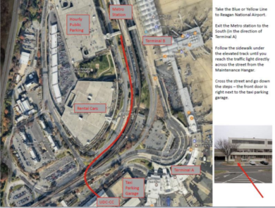
Directions to Reagan National Airport, Hangar #2
Address
2801 Thomas Avenue, Hangar #2
Ronald Reagan Washington National Airport (DCA)
Washington, DC 20001
Directions by Metro Rail
Reagan National Airport Metro Station (near Hanger #2)
View Metro Map
Metro Line: Blue and Yellow Lines
Driving Directions
Driving directions from DC:
- Travel South on 395 and cross the 14 Street Bridge into Virginia.
- Take exit 10B (2nd right after crossing the bridge) George Washington Memorial Parkway South – the sign says Reagan Nat’l Airport and Mount Vernon.
- In the right lane crossing the bridge, be prepared to cross over a few lanes on the right to get into the exit lane
- Merge onto the GW Parkway and stay in the right lane.
- Take the first airport exit and follow the signs to Terminal A hourly parking.
- Exit the parking garage in the direction of the Metro station and follow the walking directions (listed above).
Driving Directions from Maryland:
Baltimore and Prince George’s County:
- Travel South on I-95 over the Woodrow Wilson Bridge into Virginia.
- Take exit 177B and merge onto Route 1 North.
- Take the Airport Exit and follow the signs to Terminal A hourly parking.
- Exit the parking garage in the direction of the Metro station and follow the walking directions (listed above).
Frederick & Montgomery Counties:
- Travel south on I-270 towards Washington, DC
- Follow I-495 South (outer loop) towards Northern Virginia.
- Take exit 43 George Washington Memorial Parkway South.
- Take the Airport Exit and follow the signs to Terminal A hourly parking.
- Exit the parking garage in the direction of the Metro station and follow the walking directions (listed above).
Driving Directions from Virginia:
Richmond and Points South:
- Travel North on I-95 North to I-395 North.
- Take exit 10 (George Washington Memorial Parkway South); stay in the right lane.
- Take the first airport exit and follow the signs to Terminal A hourly parking.
- Exit the parking garage in the direction of the Metro station, and follow the walking directions (listed above).
Manassas and Points West:
- Travel East on I-66 East and take Route 110 South to Route 1 South.
- Take the Airport Exit and follow the signs to Terminal A hourly parking.
- Exit the parking garage in the direction of the Metro station and follow the walking directions (listed above).